Property Record
19 E Reed Rd, La Fayette, GA 30728
NEARBY LISTINGS FOR SALE OR LEASE
-
-
View all La Fayette listings for sale on LoopNet.com
Property Detail
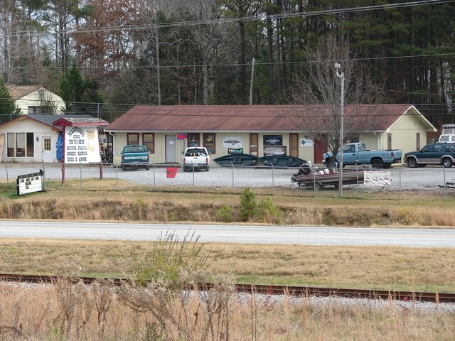
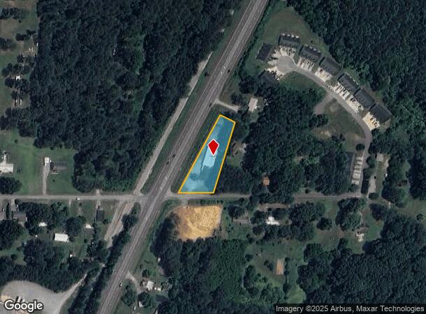
19 E Reed Rd
03212-015
Battlebluff
Commercialnec
PT LL 205 8/4
X
Walker
13295C0095D
Georgia
2024
1.03 AC
2024
Walker County
020601
Chattanooga
2,208 SF
Chattanooga, TN-GA
DEMOGRAPHICS near 19 E Reed Rd
1 Mile
3 Mile
5 Mile
2024 Total Population
2,052
9,323
16,290
2029 Population
2,151
9,784
17,012
Pop Growth 2024-2029
+ 4.82%
+ 4.94%
+ 4.43%
Average Age
41
41
41
2024 Total Households
819
3,625
6,214
HH Growth 2024-2029
+ 4.88%
+ 4.97%
+ 4.46%
Median Household Inc
$29,269
$37,134
$40,946
Avg Household Size
2.40
2.40
2.50
2024 Avg HH Vehicles
2.00
2.00
2.00
Median Home Value
$156,874
$142,748
$148,841
Median Year Built
1988
1978
1978
Nearby Places
Map Layers
Map Styles
 Street
 Aerial
- Restaurants
- Banks
- Shops
- Fitness
- Groceries
PUBLIC TRANSPORTATION
AIRPORT
Lovell Field
DRIVE
WALK
Distance
Lovell Field
40 min
22.6 mi
Freight Ports
Georgia Ports - Savannah
DRIVE
WALK
Distance
Georgia Ports - Savannah
406 min
352.5 mi
SALE & LEASE HISTORY
LISTING DATE
SALE/LEASE

Aug 04, 2017
For Sale
Apr 08, 2021
For Sale
Nearby Properties
Address
Land Use
TOTAL SIZE
Lot Size
Zoning
Address
Land Use
TOTAL SIZE
Lot Size
Zoning
393,974 SF
23.02 AC
I
Address
Land Use
TOTAL SIZE
Lot Size
Zoning
194,702 SF
320 AC
A1
Address
Land Use
TOTAL SIZE
Lot Size
Zoning
149,023 SF
18.68 AC
B2
Address
Land Use
TOTAL SIZE
Lot Size
Zoning
113,243 SF
13.53 AC
I2
Address
Land Use
TOTAL SIZE
Lot Size
Zoning
75,000 SF
13.22 AC
I2
Address
Land Use
TOTAL SIZE
Lot Size
Zoning
912 SF
323.16 AC
I
Address
Land Use
TOTAL SIZE
Lot Size
Zoning
40,208 SF
3.96 AC
B2
Address
Land Use
TOTAL SIZE
Lot Size
Zoning
71,920 SF
9.69 AC
I2
Address
Land Use
TOTAL SIZE
Lot Size
Zoning
414.45 AC
A1
Address
Land Use
TOTAL SIZE
Lot Size
Zoning
73,601 SF
29 AC
R1
Address
Land Use
TOTAL SIZE
Lot Size
Zoning
41,620 SF
4.40 AC
B2
Address
Land Use
TOTAL SIZE
Lot Size
Zoning
24,002 SF
5.96 AC
B2
Address
Land Use
TOTAL SIZE
Lot Size
Zoning
2,100 SF
4.34 AC
C1
Address
Land Use
TOTAL SIZE
Lot Size
Zoning
4,564 SF
2.33 AC
B2
Address
Land Use
TOTAL SIZE
Lot Size
Zoning
49,400 SF
4.67 AC
I
Address
Land Use
TOTAL SIZE
Lot Size
Zoning
88.13 AC
R2
Address
Land Use
TOTAL SIZE
Lot Size
Zoning
15,826 SF
1.53 AC
B2
Address
Land Use
TOTAL SIZE
Lot Size
Zoning
2,243 SF
12.85 AC
B2
Address
Land Use
TOTAL SIZE
Lot Size
Zoning
3,456 SF
3.32 AC
LFL1
Address
Land Use
TOTAL SIZE
Lot Size
Zoning
14,640 SF
1.45 AC
B2
Address
Land Use
TOTAL SIZE
Lot Size
Zoning
3,200 SF
2.10 AC
B2
Address
Land Use
TOTAL SIZE
Lot Size
Zoning
20,000 SF
3.04 AC
B2
Address
Land Use
TOTAL SIZE
Lot Size
Zoning
96,263 SF
17.92 AC
B2
Address
Land Use
TOTAL SIZE
Lot Size
Zoning
5,480 SF
4.47 AC
B2
Address
Land Use
TOTAL SIZE
Lot Size
Zoning
4,912 SF
1.34 AC
B2
Address
Land Use
TOTAL SIZE
Lot Size
Zoning
4,644 SF
0.97 AC
B2
Address
Land Use
TOTAL SIZE
Lot Size
Zoning
14,220 SF
3.88 AC
B2
Address
Land Use
TOTAL SIZE
Lot Size
Zoning
8,680 SF
1.45 AC
C1
Address
Land Use
TOTAL SIZE
Lot Size
Zoning
688.27 AC
A1
Address
Land Use
TOTAL SIZE
Lot Size
Zoning
9.96 AC
B2
The World's #1 Commercial Real Estate Marketplace
Connect with us
© 2025 CoStar Group
The information above has been obtained from sources believed reliable. While we do not doubt its accuracy we have not verified it and make no guarantee, warranty or representation about it. It is your responsibility to independently confirm its accuracy and completeness. Any projections, opinions, assumptions, or estimates used are for example only and do not represent the current or future performance of the property. The value of this transaction to you depends on tax and other factors which should be evaluated by your tax, financial, and legal advisors. You and your advisors should conduct a careful, independent investigation of the property to determine to your satisfaction the suitability of the property for your needs.